Agricultural Data Collection
From overview photos, thermal, and multispectral
Service Description
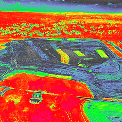
Utilize specialty payloads and lenses for capturing essential agrarian data; whether it be normal photography overviews for crop location and planning, to thermal imagery for soil water/moisture information, or multispectral images providing farmers with early, detailed insights into crop and soil health that are not visible to the naked eye, enabling precise resource management like targeted fertilizer and water application, early detection of pests and diseases, accurate yield prediction, and the ability to map fields and monitor growth for increased efficiency, higher yields, and more sustainable practices. Contact us to book services.


Cancellation Policy
To cancel or reschedule a proposed flight date, please contact us at jrwofads@gmail.com at least 24 hours prior to the proposed flight date.